
|
| Digital Monarch Watch | Guided Research Data Analysis |
|
 Creating
 the Context [Monarch Tagging] Home Research Focus Background Info Research Data Submission Results of Study Data Analysis Conclusion Further Research Guided Research [Vector & Orientation] Research Question Background Info Research Methodology Data Submission Results of Study Data Analysis Conclusion Further Research Research Values Student Research Doing Research Publish View Quick & Easy Map the Wave! Tools Discussion Forum
|
So, now that I have my data, what do I do with it? Visualizing Data Graphs are one way to visualize data and to help the researcher look for patterns. A graph is used to show the relationships of data collected from the experiment. Graphs must be constructed accurately and accoring to accepted rules. Vanishing bearing and body orientation data can be represented as dots along the outside edge of an empty circle. By convention, the top of the circle (the "twelve o'clock" position) is marked North or 0 degrees. So, a Monarch vanishing while flying due south (180 degrees) would be represented by a dot directly opposite the top of the circle, in the "six o'clock" position. Three Monarchs flying south, then, would be represented as three dots under the circle, one directly beneath the other. An additional Monarch flying to the southeast (135 degrees) would appear in the "4:30" position. And so on. This type of a graph will give you a clear visual representation of your findings that is often more telling than the tables used to collect the data initially. Statistics are also a valuable tool for looking at data and giving meaning to it. If you are not familar with satistical reasoning you can get more specifics on using this tool and what satistical test to use at DIGSTATS. If you are familar with statistics, use the results of your analysis in your conclusion. Using Geographic Information Systems for Analysis A geographic information system (GIS) is a computer-based tool for mapping and analyzing things that exist and events that happen on earth. The data that we have collected as a part of this project is well suited to GIS technology because it has a critical geographic dimension. GIS integrates common database operations such as query and statistical analysis with the unique visualization and geographic analysis benefits offered by maps. These abilities distinguish GIS from other types of analysis. Mapmaking and geographic analysis are not new, but a GIS performs these tasks better and faster than do the old manual methods. And, before GIS technology, only a few people had the skills necessary to use geographic information to help with decision making and problem solving. 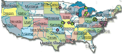 A GIS stores information about the world as a collection of thematic layers that can be linked together by geography. This simple but extremely powerful and versatile many real-world problems from tracking delivery vehicles, to recording details of planning applications, to modeling global atmospheric circulation. I would like to work with the data in a map-based format.
|
| © 1996-2006 PathFinder Science |